Timber Hunt Maps Hunting Land
Install Now
Timber Hunt Maps Hunting Land

Timber Hunt Maps Hunting Land

GPS offline maps public private BLM land property lines outdoor recreation

Developer: Timber Map Designs
App Size: Varies With Device
Release Date: Sep 30, 2023
Price: Free
Price
Free
Size
Varies With Device

Screenshots for App

Mobile
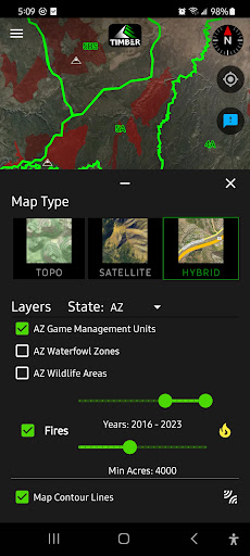
Hunt on land with precise GPS location and land ownership boundaries to help you navigate the backcountry. At Timber Hunt Maps our passion is hunting and the outdoors. We provide you with the tools you need to succeed in the field. We offer all 50 state game management units, walk-ins, hunt zones, wildlife areas, and public hunting opportunities.

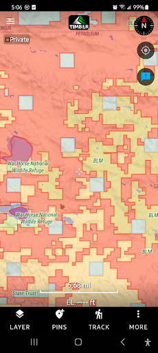
In addition we offer many customizable layers including: Fire Layer, Contour Lines, Private Land, State Trust Land, Bureau of Land Management (BLM), County, Local Government, Bureau of Reclamation, Federal Lands, US Fish and Wildlife, Hiking Trails, Trailheads, Camp Sites, and more.

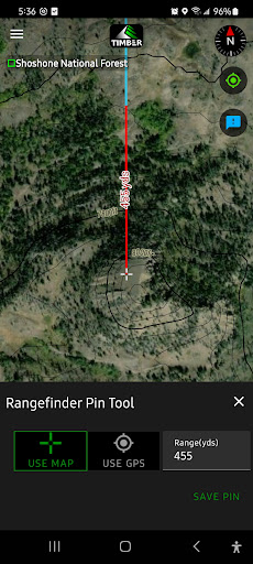
- Save your pin or waypoint
- Rangefinder Pin Tool
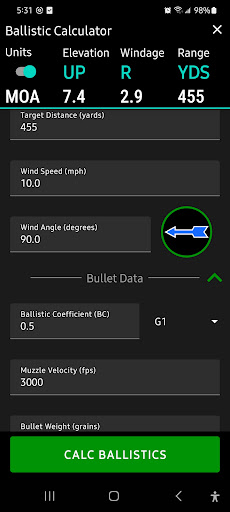
- Ballistic Calculator
- Track your movement
- Free download offline map (very large area)
- Topo (topographic), Satellite and Hybrid Map Layers
Show More
Show Less
Timber Hunt Maps Hunting Land 1.0.12 Update
2023-12-18 Version History
Added North Dakota Electronically Posted Private Land
Updated Colorado Walk-in areas

~Timber Map Designs
More Information about: Timber Hunt Maps Hunting Land
Price: Free
Version: 1.0.12
Downloads: 36
Compatibility: Android 6.0
Bundle Id: app.timbermaps.hunting
Size: Varies With Device
Last Update: 2023-12-18
Content Rating: Everyone
Release Date: Sep 30, 2023
Content Rating: Everyone
Developer: Timber Map Designs


Whatsapp
Vkontakte
Telegram
Reddit
Pinterest
Linkedin
Hide