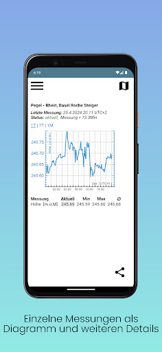
The cantonal water gauge network BS provides the current water level data in the Basel-City area. In terms of content, the measuring points of the federal government (FOEN/Hydrology) and the canton (civil engineering office) are available.
In the map display, the water axes of the main bodies of water (Rhine, Birs, Birsig and Wiese) are actively colored according to the federal flood danger level. Individual graphics for the respective levels include measurement and discharge values, and in some cases also forecast data.
Via push notifications, the app enables warnings regarding the flood warning levels on the one hand and the high water marks for navigation on the Rhine on the other.
Publisher: Basel-Stadt civil engineering department, documentation and surveying