A learning tool on seismic activity, volcanoes, and emergencies in Peru. For students, educators, and researchers.
? VERIFIED SCIENTIFIC SOURCES: • USGS - United States Geological Survey • EMSC - European-Mediterranean Seismological Center
• GeoFon - GFZ Potsdam Institute, Germany • CSN - National Seismological Center of Chile • IGP - Geophysical Institute of Peru • IRIS - International Seismology Consortium
? EDUCATIONAL EARTHQUAKES • Visualization of recent seismic events • Data: magnitude, depth, location, date • Color-coded by intensity • Updated every 15-30 minutes from multiple sources
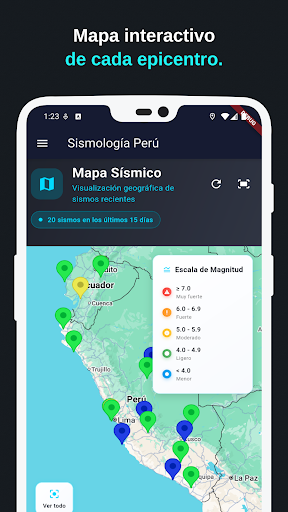
?️ INTERACTIVE MAPS • Geolocation of earthquakes from the last 15 days • Types: normal, satellite, terrain, hybrid • Markers colored by magnitude • Zoom and navigation controls
? PERUVIAN VOLCANOES • Complete database of Peruvian volcanoes • Filtered by region (15) and status • Details: elevation, type, last eruption • List view and scientific information
? EMERGENCY DIRECTORY • 16 organized official contacts • Urgent view: 4 priority numbers • Filtered by category • Direct call with confirmation
⚠️ IMPORTANT LIMITATIONS: • Data delays 5-30 minutes • NO official emergency alerts • DOES NOT replace official alert systems • NOT for critical safety decisions • Educational and informational purposes only.
⚠️ IMPORTANT DISCLAIMER: This app is NOT official and does NOT represent the Peruvian government or any government institution. It is an independent educational project using public scientific data.