1. OBJECTIVE
The objective of this experiment is to carry out an altimetric survey, aiming to demonstrate the techniques and tools used, as well as its procedure.
At the end of the experiment, you should be able to:
• carry out elevation surveys using specific instruments such as a topographic level, topographic sight and tripod;
• use software such as Excel to organize and calculate collected data, and AutoCAD to graphically represent topographic data;
• plan and execute a topographic survey in the field, considering the practical and logistical aspects necessary for accurate data collection.
2. WHERE TO USE THESE CONCEPTS?
The practice of topographic surveying, focused on altimetry, is essential to train engineers capable of carrying out precise measurements of level differences on land. This skill is fundamental for planning and executing projects in various areas of engineering, such as civil construction, highways, dams and urban planning.
Mastering topography and georeferencing techniques allows engineers to accurately interpret and modify the environment, ensuring that infrastructures are built safely and efficiently. Furthermore, the ability to apply this knowledge to real projects significantly improves decision making and resource management.
Why Learn these Techniques:
1. Precision in Planning: Topography provides essential data for the correct dimensioning and leveling of land, avoiding errors that could result in structural failures.
2. Efficiency in Project Execution: With the use of instruments such as the topographic level and software such as AutoCAD and Excel, engineers can optimize processes and reduce costs.
3. Technological Adaptation: Familiarity with advanced technologies and engineering software prepares professionals for the contemporary demands of the job market.
3. THE EXPERIMENT
In this experiment you will carry out an altimetric survey using leveling techniques. To do so, you will visit a piece of land to measure, with the aid of a topographic sight and level, the differences in height between points previously marked with pickets. The collected data will then be processed in Excel for leveling calculations and graphically represented in AutoCAD. This practice not only reinforces the use of specific technologies, but also develops analytical and practical skills relevant to civil engineering and surveying.
4. SECURITY
When it comes to field practice, you must be prepared to protect yourself from potential dehydration and heatstroke caused by excess solar radiation. Therefore, you should use:
Sunscreen;
Hat, cap or Arab headdress – as needed;
Canteen or bottle with water;
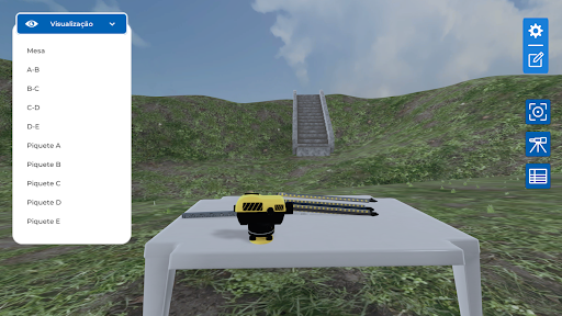
5. SCENARIO
The practice will be carried out on terrain with different heights, with 5 points marked with pickets and nails. A topographic sight, a topographic level with a tripod will be available to the student.