ATTENTION: This is an ATAK Plugin. To use this extended capability, the ATAK baseline must be installed. Download the ATAK baseline here: https://play.google.com/store/apps/details?id=com.atakmap.app.civ
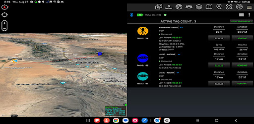
ATOS is an organic Line of Sight (LOS) tracking system that runs inside of ATAK and can track virtually any object to include MWDs, sUAS, personnel, vehicles, aircraft, and parachute bundles. ATOS operates in the UHF spectrum, independent of cellular, WiFi or satellite networks. The Command Link connects via Blue Tooth to an ATAK EUD and can communicate via UHF with tags at a range of 1 to 4 miles, increasing to 30+ miles in the air. The user can choose to broadcast the location of tags over their ATAK network using mesh network radios or the internet. The tracks and other symbols are displayed as Cursor on Target (CoT) data. ATOS provides the user the ability to track and monitor the real time location of 200+ tags.
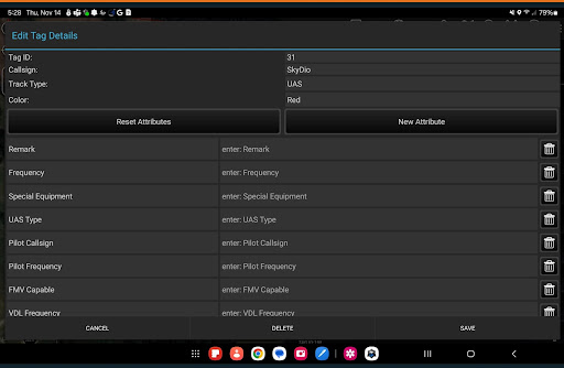
Use the ATOS manifest tool to customize your tags to suit your mission. Manifests can be shared through ATAK, TAK Servers, or through Android's Quick Share in order to keep everyone in the mission on the same page.
The ATOS track history tool is a core feature that automatically logs tag geospatial data during missions. This data is saved to a database on the phone, enabling users to review it without any network connectivity.
Access the ATOS manifest and track history tools by using the ATOS ATAK plugin, or via the built-in ATOS standalone app.
https://toughstump.com/