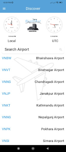
In the dynamic and often unpredictable environment of aviation, the significance of weather information cannot be overstated. Weather plays a critical role in flight planning, aircraft operation, navigation, and safety assurance. In Nepal, the challenge of aviation is heightened by the country's complex topography, rapidly changing meteorological conditions, and limited availability of localized aviation weather data. The development of a specialized weather application for aviation stakeholders in Nepal seeks to address these challenges by offering real-time, accurate, and location-specific weather updates to enhance flight safety, operational efficiency, and informed decision-making.
This application is specifically tailored to meet the needs of aviation stakeholders operating within Nepal’s airspace. These stakeholders include pilots, commercial airlines, airport authorities, and air traffic controllers. Each of these groups relies heavily on weather data to execute their respective responsibilities efficiently and safely. The app aims to become a crucial tool that supports day-to-day operations and long-term strategic planning within the aviation ecosystem.
As part of our continuous effort to enhance flight safety, operational efficiency, and informed
decision-making, the application will include the following features:
Real-time METAR and TAF data
Aerodrome-specific forecasts
SIGMETs and other aviation warnings
Satellite imagery and Weather Camera Images
Other weather information tailored to Nepal's complex topography and airspace.