An off-line hiking app for the Anza-Borrego Desert and surrounding area.
You can download 4 free Anza-Borrego Desert off-line topo / hiking maps and 1 free satellite map.
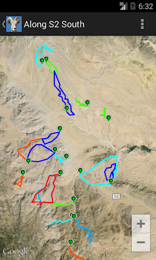
With pre loaded hikes and dirt roads from BorregoHiking.com.
Switch on the GPS and drive up to the trail head.
You can enable the dirt/wash road layer to show the last known location of a dirt road.
This App allows you to record your own trip and add your own markers.
After the hike export your trip to a GPX file, that can be read by e.g. Google Earth.
Import GPX files from other sources and show them on the map.
About the park:
The Anza-Borrego Desert is one of the best places for cross country hiking.
It's vast and varied terrain are ideal for day hikes, the hiking times vary from 1 to 8 hours in a brisk pace.
You might want to check our website BorregoHiking.com to find out if this is the place for you.
The park offers only a couple of real marked hiking trails, most of the hikes don't follow any trail, but follow the washes the terrain or go cross country. By foot, this is perfectly legal in most parts of the park, when in doubt check at the visitor center in Borrego Springs.
Safe hiking, we are out hiking most of the time, see you,
Carla and Fred.
Borrego Springs Ca.
P.S comment on our Facebook page https://www.facebook.com/Borregohiking
Give us a like, or request new features.
Warning:
Use a high speed WiFi connection to download the maps. Be aware that the Extra maps are very large, up to 3 Giga Byte.
As wash road can change dramatically, watch out where you drive and be prepared. Check for road conditions at the Visitor Center in Borrego Springs.
Always read the hiking description before a hike.
The App allows you to follow our trails, but be aware that some hikes may be (too) challenging for you.
Read the disclaimer carefully before you use this App.
Some hikes are for experienced hikers only and may contain boulders, slippery canyons, steep terrain and otherwise dangerous terrain.
Temperatures can vary from cold to extremely and dangerously hot. From May up to October a long hike in the low desert isn't recommended.
Make sure you don't wander into a prohibited area like the Carrizo impact area or private property.