Capture. Geotag. Share. Explore.
Geotag Camera is your essential tool for stamping accurate GPS location, time, and map data on your photos. Whether you're a traveler, hiker, photographer, or just love documenting moments—this app makes it easy, efficient, and elegant.
🌟 WHY CHOOSE THIS APP?
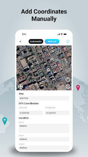
• Accurate Geotagging – Instantly embed GPS coordinates, address, and time on your photos
• Live Map Integration – View and verify your photo’s location on an interactive map
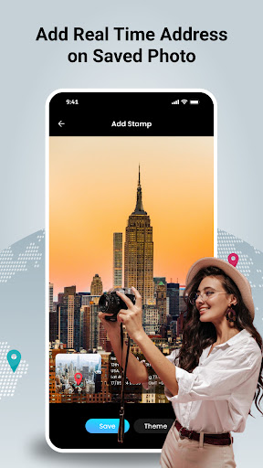
• Customizable Stamps – Choose styles, layouts, font size, date format, and more
• Easy Save & Share – Save photos with geotags and share via social media, email, or cloud
🧭 Perfect for Every Adventure
Whether you're exploring new trails or capturing your next photo shoot:
• Travelers – Document places with precision
• Hikers – Keep a visual log of your trail history
• Photographers – Organize shoots with geolocation data
• Outdoor Enthusiasts – Create shareable geo-memories in seconds
📸 How It Works
→ Enable GPS Tracking – Ensure accurate location services
→ Take or Upload Photos – Use built-in camera or import from gallery
→ Add Geolocation Stamps – Customize date, time, location, and format
→ View on Map – Track exactly where each photo was taken
→ Save & Share – Export photos in HD with embedded stamps
🚀 Key Benefits of Using Geotag Camera
→ Enhanced Photo Organization – Filter images by time or location
→ Professional Geotagging – Ideal for fieldwork, evidence capture, and journaling
→ User-Friendly Interface – Simple and fast design, no learning curve
📍 Start geotagging your memories today with one smart tap. Whether it’s for fun, work, or creative projects, Geotag: Geolocation GPS Stamp helps you tell better location-based stories through your photos.