GeoTag Camera: GPS Photo helps you capture photos with automatic location stamps, GPS coordinates, maps, address, date, and time.
Perfect for field workers, surveys, inspections, deliveries, project reporting, real-estate documentation, and evidence collection.
⭐ Key Features
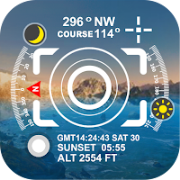
📍 Auto Geo-Tagging: Add latitude, longitude & address to photos.
🗺️ Map Overlay: Show map preview on each photo.
⏱️ Date & Time Stamp: Automatic timestamp for every picture.
📁 Organize by Folder: Easily manage work photos.
📤 Share Instantly: Send geo-tagged photos to clients or teams.
🎨 Custom Templates: Choose stamp style, color & layout.
✔️ Accurate GPS Capture: Works with high precision even offline.
🌍 Who Uses This App?
Field surveyors
Construction & site inspectors
Delivery & logistics teams
Real estate agents
Farmers & agronomists
Security & maintenance staff
Utility companies
Government and NGO projects
💼 Why Choose GeoTag Camera?
GeoTag Camera makes professional reporting easy. Whether you’re documenting work progress, verifying location, or collecting evidence, this app ensures every photo is accurate, time-stamped, and location-verified.