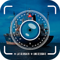
GPS map camera: location stamp app is an advanced mapping app that captures photos with GPS location data. Using the GPS location feature of this app, photos you take includes the map camera location, timestamp, longitude and latitude. This GPS camera photo with location and timestamp ensures you always remember where each moment happened. The camera geotagging app comes with multiple templates so you can easily customise the photo location and timestamp.
The GPS location camera adds a map camera timestamp, so your pictures include a location, but also the exact time they were taken using the camera geotagging. Whether you're travelling, or simply exploring your phone gallery, the GPS Map camera with coordinates on your photos lets you know where the photos was clicked. With Camera geotagging, every photo with location and time becomes a record that makes you look back on your memories with full details like location, longitude, latitude and time. .
Key Features of GPS Map Camera: Location Stamp
● Capture photos with GPS camera geotagging
● Automatically tag images with a photo date time stamp and map camera location.
● Use a GPS map camera with longitude and latitude to pinpoint where each shot is taken.
● You can easily share GPS camera photos with location and timestamp directly with friends and family
● The GPS map camera and photo timestamp features are best for travellers, tourists, or anyone who wants to record their experiences.
● With the GPS map camera: Location stamp, capture photos with timestamps and GPS map location data
● The GPS camera photo with location feature allows you to customize settings like time-lapse, aspect ratio, and other parameters according to your preferences.
Download the GPS Map Camera: Location stamp app today and start exploring the world while documenting your journey with camera geo tagging, photo timestamps with location data. Capture every photo with GPS coordinates, and ensure every moment is remembered with a photo timestamp and map camera location.