"Kaisoku AR" is an AR (augmented reality) application for the construction industry that projects a 3D model into the real world through a tablet and allows anyone to visualize the shape of the construction work.
This app uses patented technology to achieve high-precision positioning, and is an unprecedented, innovative system that utilizes the high-performance positioning accuracy of surveying equipment to enable positioning anytime, anywhere. (Patent No. 6733127)
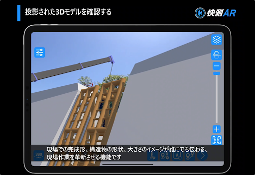
Utilizing 3D models created with the "INNOSITE series", it is not only possible to share images among construction parties, but also to communicate with the client and neighboring residents, such as confirmation of buried objects and explanation of work, which was previously difficult to convey before construction. By projecting 3D models, we can provide explanations that accurately convey your imagination.
In conjunction with Kaisoku Navi, it supports the site by projecting 3D models with highly accurate positioning. “Kaisoku AR” shows off “sites that anyone can understand”!
*In order to use this app, you will need a cloud service contract (paid) for Kaisoku AR.
Features of “Kaisoku AR”
1.Share images by placing 3D models
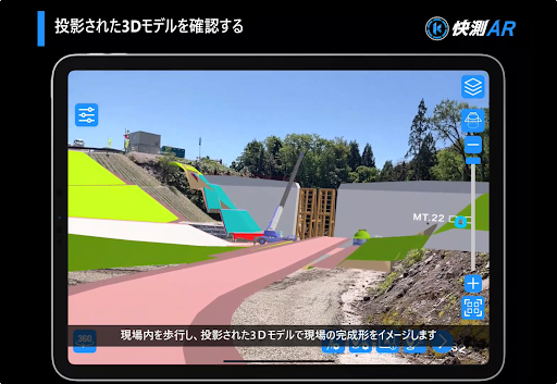
By arranging 3D data, it is easy to visualize the completed form even before construction.
In addition, the 3D model can be displayed/hidden for each layer, so depending on the construction step,
You can check the concrete image and share the status of each process.
2. Project 3D models easily and with high precision! High-precision positioning anywhere with KENTEM markers and "Kaisoku Navi"
Place the "KENTEM marker" anywhere and observe the center of the marker with "Kaisoku Navi". Use the QR code of the observed coordinate values with “Kaisoku AR”
Automatically recognizes markers by loading.
Enables reliable alignment anywhere. Even if the 3D model shifts, you can easily reposition it again.
3. Projecting the 3D integrated model created with the INNOSiTE series
3D models created with "SiTECH 3D", "SiTE-NEXUS", and "SiTE-STRUCTURE" can be output to "Kaisoku AR".
3D illustrations imported into "SiTE-NEXUS" as an integrated model and other 3D data (IFC, Sketchup, etc.) can also be output to "Kaisoku AR".
Is possible.
Keywords: civil engineering, construction management, construction system, Dexpert, INNOSiTE, Innosite, surveying, Kaisoku, Kaisoku AR, Kaisoku, AR, Kaisoku Navi, visualization