The Kropeo mobile application is linked to the web application. It is used in the field. It gives access to a map on which all the elements useful for the organization of construction sites and the management of drivers are present.
From the mobile application map, the driver can:
- Create a location (plot, pile, etc.) by locating it and providing information on it.
- View information about a location.
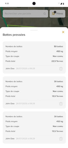
- Enter data via input forms (tonnage spread, bales pressed, etc.).
- Change location status to notify what has been done or what needs to be done.
- Open a route in Maps to reach a localized location.
- Find the location of another driver and know the time of their last connection.
In 2025, Kropeo opens up to all agricultural and forestry activities by becoming customizable to each company. Kropeo adapts perfectly to your needs and its implementation is simplified.
The mobile application cannot be used alone and it is not possible to create an account from mobile. You must take out a Kropeo subscription or request a demo on the internal website www.kropeo.fr.