Visualize and compare your topographic data with ease!
This innovative application lets you open and display .pnt files in both 2D and 3D, providing engineers, surveyors, and geomatics professionals with powerful tools for terrain analysis and comparison.
Key Features:
📂 Import .pnt files containing coordinates (X, Y, Z) and point names
🧭 Interactive 2D display inspired by AutoCAD
🔍 Zoom in/out and hover to see point details
🗺️ 3D visualization with Viridis color palette to highlight elevations
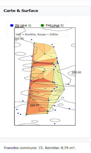
⚖️ Compare field measurements with CAD data to spot differences
Benefits:
🚀 Fast and intuitive PNT file viewer
🎯 Accurate topographic survey comparisons
📱 Clear, responsive, and easy-to-use interface
Perfect for engineers, surveyors, and geomatics professionals.