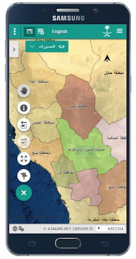
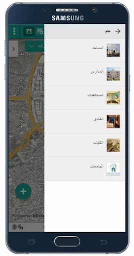
Spatial Data Infrastructure Program (SDI) is one of the initiatives of the Madinah Development Authority.The program is continuously developing it to make geospatial data accessible to individuals and organizations within the framework of policies, regulatory procedures and international standards to facilitate exchange between all parties involved in the program.
برنامج البنية التحتية للبيانات المكانية أحد مبادرات هيئة تطوير منطقة المدينة المنورة، ويعمل القائمين على البرنامج الى تطويره بإستمرار لجعل البيانات الجيومكانية في متناول الجهات والأفراد ضمن سياسات وإجراءات تنظيمية ومعايير قياسية بمواصفات عالمية لتسهيل عملية تبادلها بين جميع الجهات المشاركة في البرنامج.
~Al Madinah Al Munawarah Development Authority(MDA)
1.0 1.0
برنامج البنية التحتية للبيانات المكانية أحد مبادرات هيئة تطوير منطقة المدينة المنورة، ويعمل القائمين على البرنامج الى تطويره بإستمرار لجعل البيانات الجيومكانية في متناول الجهات والأفراد ضمن سياسات وإجراءات تنظيمية ومعايير قياسية بمواصفات عالمية لتسهيل عملية تبادلها بين جميع الجهات المشاركة في البرنامج.
~ Al Madinah Al Munawarah Development Authority(MDA)
More Information about: البوابة الجيومكانية لمنطقة الم
Price:Free
Version:1.0
Downloads:370
Compatibility:Android 5.0
Bundle Id:com.mda.geoportal
Size:Varies With Device
Last Update:2019-10-10
Content Rating:Teen
Release Date:Oct 9, 2019
Content Rating:Teen
Developer:Al Madinah Al Munawarah Development Authority(MDA)