IoT technology creates an ecosystem and platform for digital transformation that connects the community through work, location and time
Receive activation code via Zalo 0979219560
A smart and handy pocket tool that you always carry with you, as a virtual assistant, as a companion to support cartographers, Cadastral, Forestry, XD, GT, TL, etc... on every project
Calculate the full coordinates and support the maintenance and development of the network of coordinate points, elevations in Vietnam, for you to measure the map for reference, easily edit more and less management of landmarks, find landmarks in the field, serving the effective exploitation of geodetic networks in infrastructure construction and socio-economic development. The main functions include:
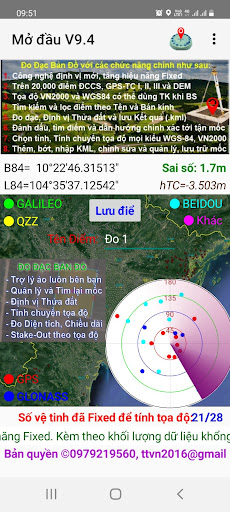
1. Using new positioning technology, enhanced accuracy and Fixed effect.
2. 24,700 landmarks controlling coordinates and altitudes cover provinces, borders, islands, territories, and coastal areas nationwide. The VN2000 and WGS84 coordinates of the point can be used as a reference when correcting
3. Measure the absolute RTK to coordinates VN2000 and the height of the water level, save the point and output to kml, txt files. StakeOut in VN2000 coordinates. Combining GNSS positioning with clear features on the image background and precise coordinate calculation techniques to produce VN2000 coordinates of the point more accurately.
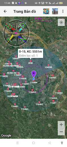
4. Find point by approximate name and filter point by radius around current position or position by input coordinates
5. Mark circles and filtered points on Google Map, Google Earth
6. Mark, find smart points accurately up to the landmarks in the field
7. Calculating coordinates of all types, just enter 1 coordinate type, the remaining 6 types will be calculated on VN2000 and WGS84. Calculate transfer for points and also KML . file
8. Add or remove points, import KML files, edit notes and manage and archive the landmark catalog library with exact coordinates for long-term use.
9. Deploy points on a diverse map background, interaction between selected points on the map and the list of points in the database, coordinates easily rotate between parts of positioning, calculating transfer, expanding points and adding points to the database
10. Import KML and PNG drawings and support locating land plots, measuring distances and areas on Google Map, Google Earth background.