Take informed decisions based on accurate and reliable positioning data with PinPoint-GIS from Septentrio.
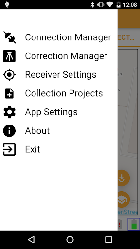
PinPoint-GIS allows you to use Septentrio GNSS receivers in the field with any Android mobile device and allows you to perform basic data collection using your Septentrio receiver. By using PinPoint-GIS, you can control your GNSS receiver from the palm of your hand and gain Septentrio’s renowned accurate and reliable DGPS/RTK positioning for any Android GIS app running on your mobile device. While PinPoint-GIS App can be left running on the background you can then use a Survey, GIS or mapping application of your choice (such as Collector for ArcGIS, MapIt, QGIS for Android, and many other Android applications).
Features include:
• Connection to Septentrio receivers via Bluetooth or IP (via Wi-Fi or GSM internet connection)
• Connection manager for easy connection setup and prioritization of the order of your preferred connections to Septentrio receivers
• Android Location Overriding to use any other GIS, Survey or mapping application benefiting from the accurate and reliable Septentrio GNSS receiver
• A unique accuracy widget with custom levels for easy monitoring the GNSS position error (horizontal and vertical)
• Android notifications based on your custom accuracy levels while running your own application
• Control NTRIP, Cell, Logging, Antenna height, etc of your Septentrio GNSS receiver
• Customer connection script support (ASCII file with receiver commands for your preferred custom configuration)
• NTRIP with auto-reconnect functionality allowing you to get real-time differential corrections for achieving a high accuracy GNSS solution (using your tablet's mobile connection)
• Point data collection into a CSV file using Septentrio’s PinPoint-GIS Rx (data collection) option*
• Custom field definition of receiver attributes for your data collection*
• Stop and Go tagging mechanism in the logging of raw GNSS data to allow post-processing of your collected GNSS data*
* Collection feature requires special receiver permission. Please contact Septentrio or your local dealer to obtain this functionality.