Description
This application offers a dynamic approach to the cycle 3 geography program through 23 maps of France, Europe and the world. Thanks to a check/uncheck system of layers, the elements present on the map are modular and allow the teacher to display only the desired information.
Accessible on the Jocastore.fr platform, this tool can be used online (directly from a browser) or available for download for local use.
Contents
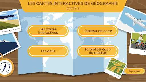
The app contains:
• 23 interactive maps (11 France maps, 4 Europe maps and 8 world maps);
• 48 digital challenges;
• 1 map editor with 3 customizable blank map backgrounds;
• 1 media library bringing together all the media offered to accompany the cards (17 videos, 5 animations, 12 captioned images, 16 slideshows, 22 “Find out more”, 132 photos and illustrations).
Goals
Locate oneself in space and build geographical landmarks:
• Name and locate major geographical landmarks.
• Name and locate a place in a geographical space.
• Name, locate and characterize spaces.
• Situate places and spaces in relation to each other.
• Understand the notion of geographic scale.
• Memorize geographical landmarks linked to the program and know how to use them in different contexts.
• Find, select and use information in a digital resource.
• Understand the general meaning of a document.
• Identify the document and know why it needs to be identified.
• Extract relevant information to answer a question.
• Appropriate and use an appropriate geographical lexicon.
• Use analog and digital maps at different scales, photographs of landscapes or places.
Summary
Interactive maps
Introduction: the tools of the geographer
• Photography
• Earth
• The planisphere
• The geography map
France
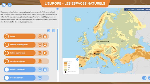
• Natural spaces
• Climatic zones
• Administrative divisions
• The population density
• Agricultural spaces
• Industrial spaces
• Tourist areas
• Electricity production
• Fresh water consumption
• Transport networks
• Internet access
Europe
• Natural spaces
• Climatic zones
• The European continent
• Transport networks
The world
• Continents and oceans
• Natural spaces
• Climatic zones
• States and territories
• France in the world
• Availability of fresh water
• Transport networks
• The Internet network
All the maps are contextualized by an introductory text, a definition for each layer and sometimes, associated complementary media. They can be displayed in full screen, can be annotated and are printable.
personalized cards
Three blank base maps (France, Europe, world) offer the possibility of creating your own maps from the layers from/items appearing in the original maps.
Challenges
38 interactive exercises allow you to take stock of the knowledge acquired thanks to the cards in a fun way.
The media library
All media is filed in the library. They can be searched by map, type of document, theme, keyword.