Measure land area & distance on map using GPS. Perfect for farming & surveying.
📏 GPS Area Calculator: Maps Tool is a smart land measurement app for calculating area and distance with precision using GPS & map-based tools. This app makes measuring fields, plots, and paths easy.
Distance Measure: Measure distance between two points on the map with our easy-to-use distance tool. Perfect for measuring fencing, roads, or paths across your land.
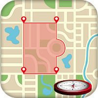
Area Calculator: Estimate land size quickly using our simple area calculator. Mark points on map to view selected area, Ideal for calculating acreage or square meter for landscaping or property management.
🎯 Perfect for:
Farmers & agriculture planning
Civil engineers & construction sites
Land surveyors & real estate agents
Outdoor trackers & landscapers
✨ Key Features:
🗺️ Draw or Tap to Measure: Add points on map to calculate area or distance instantly
🚶♂️ Live GPS Walk Mode: Walk around a boundary and view your location.
📌 POI (Points of Interest): Save & share important locations for reference
🧭 Map Modes: Satellite, Normal
📤 Share as Image: Share your measurements with clients, teams, or for record
🧰 Bonus GPS Tools:
📍 GPS Compass – Find direction with accuracy
📌 Location Share – Bookmark important places
📌 Landscape artists
📌 Landscape design
📌 Sports track measurement
📌 calculate perimeter via Map
💼 Whether you’re mapping a farm, marking construction boundaries, or just measuring your backyard, GPS Area Calculator is your go-to app!