NOT OFFICIAL - IdroRadar: PRIVATE APPLICATION FOR RIVER MONITORING
IMPORTANT NOTICE: This app is created by an independent developer and is NOT affiliated with, approved by, or connected in any way to any government body, the Emilia-Romagna Region, or ARPAE. The app uses only public data available on official websites.
IdroRadar is an NON-OFFICIAL tool that allows you to view public data on the hydrometric levels of rivers in Emilia-Romagna in a simple format. Designed by a citizen for citizens.
DATA SOURCE: All data shown comes exclusively from the Emilia-Romagna public portal available at: https://allertameteo.regione.emilia-romagna.it/ - public APIs are used and made available for development without the need for authorization (https://allertameteo.regione.emilia-romagna.it/sviluppatori)
Our app has no control over the quality or availability of this data.
FUNCTIONALITY:
📍 UNOFFICIAL MAP VIEW
- Public data displayed on interactive map
- Colored indicators to identify levels
- Customizable filters
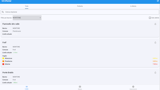
📋 STATION LIST
- List created from public domain data
- Filter and search stations
- Intuitive organization
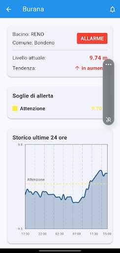
⚠️ PERSONAL NOTIFICATIONS
- Personal alerts when levels exceed thresholds
- Tracking your favorite stations
- Customizable settings
PREMIUM VERSION:
A one-time purchase (non-subscription) unlocks additional features such as multiple station monitoring, ad removal, and more frequent updates.
IMPORTANT: This app does not replace the official warning systems in any way. For emergency communications, always refer to the official channels of the Civil Protection and government bodies.
Developed by: Matteo P. -
[email protected] - PRIVATE DEVELOPER NOT ASSOCIATED WITH GOVERNMENT ENTITIES