Geotrip: Dashcam with GPS Map
Capture and Relive Your Adventures with Precision!
Geotrip is the ultimate companion for road trip enthusiasts, cyclists, motorcyclists, hikers, commuters, and professional drivers who want to document their journeys with a powerful dashcam while tracking their exact location on an interactive map. With Geotrip, every moment of your trip is recorded and synchronized with GPS coordinates, allowing you to revisit your adventures like never before.
Key Features:
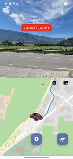
• Seamless Video Recording
Record high-quality videos of your journeys with a single tap, capturing every moment on the road or trail.
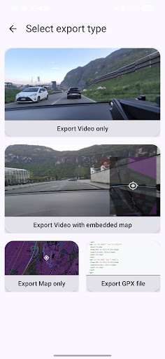
• Exports Videos with map or GPX data
• Dashcam Functionality
Use Geotrip as a reliable dashcam to continuously record your drives, providing essential footage for security, insurance, or reviewing past trips.
• Automatic GPS Tracking
Geotrip saves GPS coordinates for each timestamp in your video, mapping your entire route effortlessly.
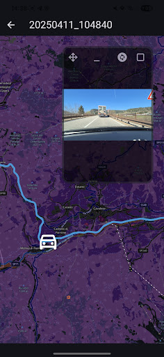
• Interactive Map Replay
Rewatch your recorded trips with an interactive map that enhances your viewing experience. As you play the video, the map dynamically displays your real-time location, allowing you to see exactly where you were at every moment of the recording. This feature helps you better understand your route, relive key moments, and analyze specific locations with ease.
• Map Cursor Navigation
The interactive map isn't just for viewing—it allows you to control video playback seamlessly. Move the cursor along the mapped route to instantly jump to the corresponding point in the video. Whether you want to revisit a scenic overlook, retrace your path to a specific stop, or review an important moment, the map provides an intuitive way to navigate through your recording.
• Precision Seeking
Easily navigate through your recordings by selecting any point on the map and watching your trip unfold from that location. This ensures that you can quickly access the exact moments that matter most without endless scrubbing through footage.
• Easy to Use
With a clean and intuitive interface, Geotrip makes it simple to capture and relive your adventures with minimal effort.
• Personalized map avatars
Generate your custom map avatars to create a fully customized experience.
Why Use Geotrip?
• Perfect for road trip lovers who want to document their travels
• Great for professional drivers who need to keep track of routes and journeys
• Useful for recalling scenic routes, special places, or even accident locations
• Perfect for cyclists and motorcyclists to track their rides
• Ideal for hikers who want to document trails and navigate back to key points
• Reliable as a dashcam for security, accident recording, and insurance claims
Use Cases:
Imagine you're on an exciting bike trip through the mountains, capturing breathtaking landscapes along the way. With Geotrip, you can later relive your adventure by watching the video while seeing exactly where you were on the interactive map. You can jump to key points in your journey, such as a scenic lookout or a challenging uphill climb, making it easy to revisit the best moments of your ride.
Alternatively, if you're using Geotrip as a dashcam, it can be a crucial tool for safety and documentation. In the event of an accident or traffic incident, you’ll have a recorded video with precise GPS data to support insurance claims or legal matters. This ensures you have verifiable evidence of your location and what happened on the road.
How It Works:
1. Start recording your trip with Geotrip.
2. The app captures video while simultaneously logging GPS coordinates.
3. When watching the video, see your precise location on the interactive map in real-time.
4. Use the map cursor to select any point on your route, instantly jumping to the exact moment in the video.