"Kodaira City Disaster Prevention Map App" is an application to browse "Kodaira City Disaster Prevention Map" on your smartphone.
You can use GPS to check the nearest evacuation site even if you do not have an internet communication environment.
We also provide information on daily preparations, knowledge in the event of a disaster, and how to confirm the safety of your family, so please use it to prepare for a disaster.
[Features]
■ Functional map
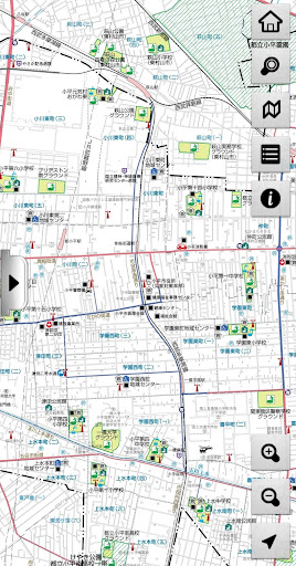
・ A map showing disaster prevention related facilities using pictograms in an easy-to-understand manner is used as a background map.
You can intuitively grasp the layout of disaster prevention related facilities.
・ When online, it is possible to switch the distribution type map service to the background map and use it.
It is possible to display a map of the outskirts of Kodaira, and it can be used from outside the city.
■ Abundant search
・ Facility search
The facility selected from the facility list is displayed on the map.
Also, by entering a part of the facility name, the selection target will be narrowed down and displayed.
It is also possible to narrow down the selection target by the type of facility.
・ Address search
Displays a map of the area selected from the list of towns and streets in the city or the list of large characters.
・ Peripheral search
The facility list is displayed in the order of the current position (when using GPS) or the distance from the center of the displayed map.
■ Convenient guidance display to the target point
・ A line connects the current position (when using GPS) or the center of the displayed map to the facility selected as the target.
・ When online, you can start the map app and search the route from your current location to your target.
[Disaster prevention information]
We provide the following disaster prevention information as a preparation for disasters.
·Earthquake countermeasures
・ Fire countermeasures
・ Wind and flood damage countermeasures
・ Comprehensive measures
=================
[Provider information]
Disaster prevention information: Kodaira City
Map information: Kodaira City, Chuo Geomatics Co., Ltd.
Product development: Chuo Geomatics Co., Ltd.
[Introduction]
・ The information on the "Kodaira City Disaster Prevention Map" posted in this app is based on the information as of May 2021.
・ Please note that we are not responsible for any troubles that may occur when using this application product.
[Contact for inquiries regarding disaster prevention maps and disaster prevention information]
Kodaira City Citizen's Life Department Disaster Prevention and Safety Division