"Yamato SOS Support App" is an official app provided by Yamato City, Kanagawa Prefecture.
This app provides a wide range of information related to crime prevention and disaster prevention, such as crime occurrences in the city, locations with frequent traffic accidents, evacuation sites in the event of a disaster, etc., in an easy-to-understand manner.
By downloading maps and content from the app in advance, you can use the app even if you are out of service area in the event of a disaster. We recommend that you download it in advance.
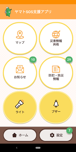
The main functions of the "Yamato SOS support application" are as follows.
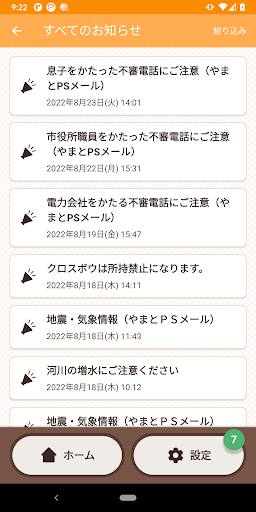
○ Notice
You will receive notifications about crimes and disasters from Yamato City and the Kanagawa Prefectural Police.
From Yamato City, you will receive "Yamato PS Mail", and from the Kanagawa Prefectural Police, you will receive a part of "Pigal-kun Child Safety Mail". If you would like to receive more detailed information on "Yamato PS Mail" and "Pigal-kun Child Safety Mail", please register from the websites of Yamato City and Kanagawa Prefectural Police.
○ Crime prevention and disaster prevention information
You can check information that is useful for crime prevention and disaster prevention.
You can also download usable information even when a disaster occurs and you are out of service area.
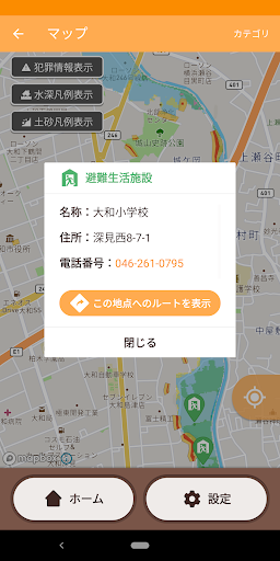
○ Map
You can check the locations and routes of evacuation shelters and AEDs (enable the GPS function).
By downloading the map in advance, you can check the map even when a disaster occurs and you are out of service area.
The information that can be confirmed is as follows.
・Locations where traffic accidents frequently occur
・Wide-area evacuation site
・Evacuation facilities
・Standpipe fire extinguishing equipment
・AED (automated external defibrillator)
・Expected flooding area
・Sediment disaster warning area
In addition, you can check the number of crime occurrences for each chome of the address.
The expected inundation areas on the map were designated by Kanagawa Prefecture based on the "largest possible rainfall (24-hour rainfall Sakai River 632 mm, Hikichi River 412 mm)". (Some areas are designated by the city based on the assumptions of Kanagawa Prefecture.)
Landslide warning areas (yellow zones) and landslide special warning areas (red zones) on the map are designated by Kanagawa Prefecture based on the Landslide Prevention Law.
Please use this map for consideration of evacuation behavior on a regular basis in preparation for emergencies.
○Disaster information sharing
Display the citizen information posting site "Kanagawa Disaster Mitigation Project" provided by Kanagawa Prefecture.
You can post and check information in the event of a disaster. You can also check the daily weather, physical sensations, and the sense of the season.
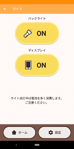
○ light
You can turn on the light and blink SOS (some functions may not be available because it depends on the function of the terminal).
Please note that the battery will be consumed a lot while the light is on.
○Buzzer
You can make a loud buzzer sound to call for help in case of emergency.
The buzzer sounds even in silent mode (some terminals may not sound in silent mode).
Also, by setting an e-mail address, you can send an e-mail containing the current location information to the set e-mail address at the same time as the buzzer sounds. Please use it after confirming that there is no error in the setting of the e-mail address and the reception rejection setting of the e-mail destination.
[Disclaimer]
The information posted in this application is distributed by Yamato City.
This application is developed and provided by DENSO CORPORATION and is not provided by any specific government agency or organization.
For details, please see the Yamato City website.
https://www.city.yamato.lg.jp/gyosei/kurashi/bosai_anzenanshin/bohan/bohanjoho/9103.html