*Note: This app requires a complete set of Smart Construction Rover devices to use.
This app is a GNSS-based measurement and guidance software offering the following features.
【Features】
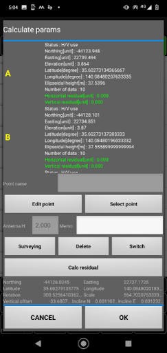
1. Localization
Easily perform high-precision localization on-site.
2. Measurement of Discrepancies Between Target Surface and Actual Condition
By importing LandXML data, you can grasp the differences from the design height in real-time.
3. Easy Integration with EARTHBRAIN Products
- Smart Construction Quick3D:
Easily link coordinates to the captured point cloud data.
- Smart Construction 3D Machine Guidance:
Quickly and easily register localization data.
- Smart Construction Dashboard:
Reflect the acquired localization data to understand the location of the construction site on the map.