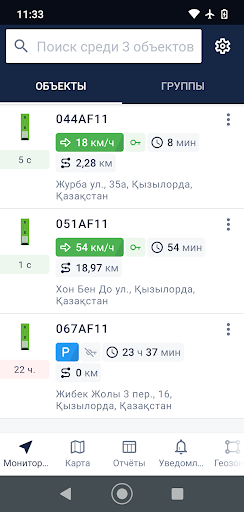
Monitor movement parameters, ignition and location of objects, as well as the relevance of the received data. Enable or disable visual display of information about the location of an object in geofences instead of address information. Send commands: messages, route, configuration request and photos from the camera for remote control of the object. Use detailed data about trips, stops, dumps and gas stations to make decisions on the spot. Monitor object events (movement, parking, refueling, draining) in chronological order and display them on the map. Access objects, geofences, tracks and event markers on the map with the ability to determine your own location.