GPS Camera Application: Discover the World with Detail and Sharpness
The GPS Camera App is a dynamic and cutting-edge tool crafted for photography lovers, adventurers, and professionals seeking to enrich their images with precise location data. By effortlessly blending live Earth maps, street views, and timestamp capabilities, this app becomes an indispensable ally for anyone who cherishes photos tied to specific places.
Key Highlights:
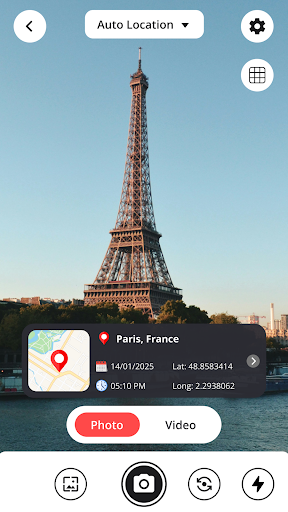
Accurate Geotagging: Snap breathtaking photos while the app automatically embeds GPS coordinates, elevation, address, and compass orientation into the image details. This ensures you'll always remember the exact spot a photo was captured, making it ideal for explorers, property experts, and field researchers.
Live Earth Map Connection: See your position on a vivid map as you shoot.
Location Function: It's a fantastic tool for city adventures, location planning, or reliving moments.
Photo Timestamp Feature: Overlay an automatic date and time stamp on your images for a precise record of the moment they were taken. Adjust the font style, size, color, and placement to suit your preferences or project needs.