LINZ Geodetic Marks
Install Now
LINZ Geodetic Marks
LINZ Geodetic Marks

LINZ Geodetic Marks

Locate nearby geodetic marks in New Zealand and update mark details

App Size: Varies With Device
Release Date: Jul 3, 2017
Price: Free
Price
Free
Size
Varies With Device

Screenshots for App

Mobile
Use the app to navigate to New Zealand's geodetic marks. You can also submit updated mark photos and other information to LINZ.

The app also includes important non-geodetic marks that may need to be protected when road and footpath works, trenching and other similar activities are being carried out.

Key features:

- Find geodetic marks and other key non-boundary marks
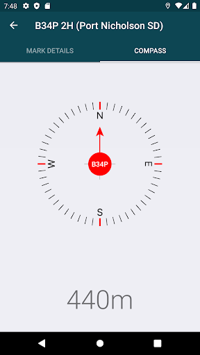
- Navigate to marks using compass and distance, or Google Maps
- Access mark details, access diagrams and photos
- Submit updated mark details and photos to LINZ
- Advise LINZ of mark maintenance issues
- Create and save mark groups
- Identify nearby PositioNZ GNSS stations
- Toggle display between horizontal and vertical marks
- Filter displayed marks by coordinate order and beacon type

You can find out more about New Zealand's geodetic marks at http://www.linz.govt.nz/gdb
Show More
Show Less
LINZ Geodetic Marks 1.6.4 Update
2022-09-19 Version History
Destroyed marks have a new symbology, making them easily identifiable, and users can display and hide the destroyed marks.

~Land Information New Zealand
More Information about: LINZ Geodetic Marks
Price: Free
Version: 1.6.4
Downloads: 5073
Compatibility: Android 4.1
Bundle Id: nz.govt.linz.GeoMarks
Size: Varies With Device
Last Update: 2022-09-19
Content Rating: Everyone
Release Date: Jul 3, 2017
Content Rating: Everyone
Developer: Land Information New Zealand


Whatsapp
Vkontakte
Telegram
Reddit
Pinterest
Linkedin
Hide