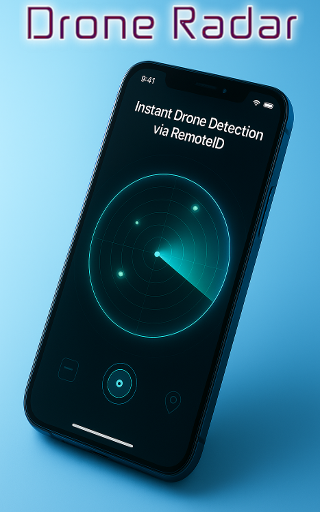
Drone Radar helps you detect, track, and find drones near you — all in real time.
Whether you’re a drone enthusiast, pilot, or simply curious about what’s flying above, Drone Radar gives you a live radar map showing active UAVs broadcasting Remote ID signals.
Using advanced Bluetooth, Wi-Fi NAN, and Wi-Fi Beacon scanning, it detects nearby drones and displays key flight details such as altitude, speed, direction, and ID — giving you a complete picture of local drone air traffic.
✈️ Key Features
? Drone Detector & Scanner – Identify drones nearby using Remote ID broadcasts.
? Live Drone Radar Map – See active drones in your area in real time.
? Drone Flight Tracker – Monitor drone altitude, speed, and flight direction.
? Drone Finder & Location Map – Pinpoint exact positions of UAVs near you.
? Bluetooth & Wi-Fi Detection – Supports all major Remote ID standards.
? FPV Radar & UAV Tracker – Detect FPV and GPS drones in your airspace.
? Open Drone ID Support – Built on open-source, standards-compliant technology.
? Drone Air Traffic View – Visualize local drone flights just like radar aviation.
? Perfect For
?Drone lovers who enjoy spotting nearby flights
?Pilots wanting awareness of other drones
?FPV racers monitoring active UAVs
?Tech enthusiasts exploring Remote ID signals
? Event organizers ensuring safe skies
⚙️ How It Works
1. Open Drone Radar anywhere — home, field, or event.
2. Tap Scan to detect active drones broadcasting Remote ID.
3. Watch them appear on your live map, complete with flight details.
Drone Radar is more than just an app — it’s your personal sky tracker, built for awareness, safety, and discovery.
Stay informed. Stay safe.
See the unseen. Explore the skies