QuickBeam Map is your go-to tool for groundtruthing and verifying geospatial features in the field. Whether you’re working with polygons, lines, or points, this app makes collecting and validating data fast, efficient, and accurate.
Perfect for professionals in GIS, mapping, surveying, agriculture, utilities, and environmental monitoring, QuickBeam Map helps teams complete data verification tasks directly from mobile devices—even in offline environments.
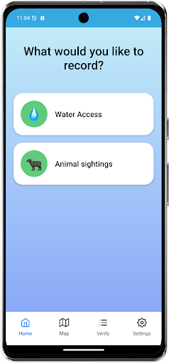
Key Features:
? Groundtruthing Made Simple
Quickly verify polygons, lines, and points using your device’s GPS. Visualise and update features directly from the field.
? Capture Supporting Evidence
Take photos, add notes, and link geospatial features to real-world evidence.
✅ Assigned Tasks & Smart Workflows
View tasks assigned to you, submit verifications, and update statuses—keeping your team in sync.
? Offline Mode
No connection? No problem. Work offline and sync data when you're back online.
? High Accuracy GPS Support
Works with your device’s GPS for reliable location tracking and validation.
? Secure Access
Sign in securely and access your organisation’s active projects.
? Real-Time Integration
Sync your field data with backend systems and dashboards in real-time.
Whether you're checking the boundary of a land parcel, confirming the path of a utility line, or validating location-based data for research or infrastructure projects, QuickBeam Map is built for accuracy and ease of use.