Roadscanner is an app which collects accessibility / obstacle information to make walkway navigation for PWDs.
[Service Features]
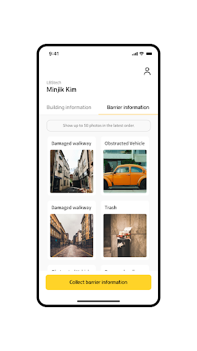
🚦 Collect obstacle information
We are collecting information that can be dangerous to the PWDs, such as steep areas where wheelchairs cannot go, illegal parking on walkways, stands, and standing signs.
🏦 Collect accessibility information
We are collecting information on the building that the PWDs need, such as the type of entrance door, the stairs of the access road, whether there is a jaw, the location of the toilet inside the building, and so on.
🌎 We dream of a barrier-free smart city, which is accessible to everyone.
We aim to provide service for constructing barrier-free smart cities that expand the scope of the PWD’s activities so that they can access the places they want.
[Useful Functions]
📲 Take a photo
- You can take a photo of the walkway and building information.
🔍 Information registration
- Obstacle information can be registered at the correct walkway by designating the obstacle location.
[Access Authority Notice]
- Location (Required): Current location
- Camera (Required) : Register walkway and building information
* You can use the service without allowing access authority, and you can change it at any time in your mobile phone settings. If you do not give permission, a request for permission will be made before you use the specific function.
* Acceptance and withdrawal of optional access is not provided if you are using a version less than Android 6.0.
📧Email:
[email protected]
📞Phone number: 070-8667-0706
😎Homepage: https://www.lbstech.net/
🎬YouTube: https://www.youtube.com/channel/UCWZxVUJq00CRYSqDmfwEaIg
👍Instagram: https://www.instagram.com/lbstech_official/
We Dream of a Barrier-Free City which is Everywhere Accessible to Everyone.
[Everywhere accessible to everyone, LBSTECH]