The Most Advanced Flight Planning and Navigation App for Pilots on Android. AvNav is for pilots who enjoy local and cross country flying through variety of terrain and weather (sometimes in IFR condition). For Flying in the United States only.
Highlights:
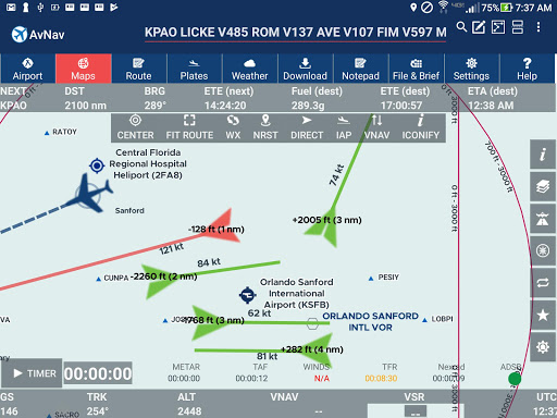
•Stitched seamless VFR Sectional, TAC and IFR charts whether its North up or Track up mode, our charts are always high quality and fast rendering
• Vector map layer shows physical features like rivers, roads, and lakes alongside aeronautical features such as air-spaces, airports and weather markers. Even details like taxiways and runways are embedded in the map.
•Victor Airways, DPs and STARs in the flight plan only Android App to do so. AvNav will insert all intermediate waypoints of an approach and provide vertical guidance along the route.
•Geo-referenced Approach plates and Airport Diagrams see your plane on Airport diagrams and Approach plates. They can also be seen as overlays on map page.
•FBO Information and Fuel prices (updated daily) are included in the App. Fuel prices can be shown on the map page itself. You can search for lower priced fuel and FBOs in the Air.
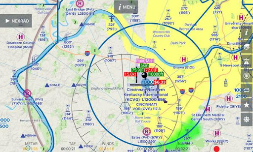
•Terrain: see terrain over your altitude in red and know that you will be able to clear terrain ahead of you. New in Version 4 is is our unique, hardware accelerated hillshading.
•In the Air, AvNav shows your GPS position on the charts and gets updated information from ADS-B receiver of your choice to display traffic and weather on the map page.
•Uncluttered Weather Icons on the Map pagesee METAR parameters such as Sky condition, Ceiling, temperature on the map page itself.
•Fast downloads via Amazon AWS- while you do not need any download other than the App to get started, for cockpit use offline charts are required and available via AWS. Our downloads are fast and you can download multiple charts at the same time. You can also continue to use the app while download is in progress.
•Preferred routes see what other pilots are filing for your origin and destination.
•Always-on rubber-banding simply drag the route to plan around SUAs, TFRs, bad weather or terrain.
•Winds aloft-optimized flight plans and Altitude optimizer do not fly without wind data - it makes a difference!
•Static and animated/looping Nexrad overlay on the map page along with Satellite imagery and AIRMET/SIGMET/PIREPs.
•TFRs, Class A, B, C Airspaces and Active or Pending SUA and MOA overlays on the map page
•DUAT Filing and Briefing - You can file an FAA Flight Plan and get weather briefing from the App itself. Most information is automatically copied from active flight plan thus reducing any need for typing.
Pricing: 30-day free trial then $74.95/year or $7.95/month - includes Fuel prices, Terrain and Geo-referenced approach plates and airport diagrams.